

Upper Indravati Right Main Canal
The Government of Odisha has approved the renovation and rehabilitation of a 42.606 km stretch (Reach-II, from chainage 41.100 km to 83.706 km) of the Upper Indravati Right Main Canal in Kalahandi district at an estimated cost of ₹239.13 crore.
OPSC Syllabus Mapping:
General Studies Paper I (Geography): Distribution of key natural resources across the world (including South Asia and the Indian subcontinent); Changes in critical geographical features (including water-bodies and ice-caps) and in flora and fauna and the effects of such changes.
General Studies Paper III (Economy & Agriculture): Major crops-cropping patterns in various parts of the country, different types of irrigation and irrigation systems storage, transport and marketing of agricultural produce and issues and related constraints; Infrastructure: Energy, Ports, Roads, Airports, Railways etc.
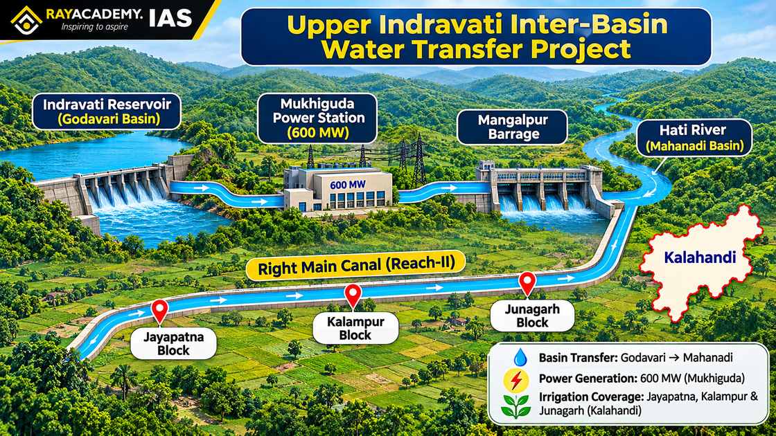
Implemented under the Canal Lining and System Rehabilitation programme, the project aims to curb seepage and transmission losses, enhance water-carrying capacity, and guarantee equitable tail-end irrigation across Jayapatna, Kalampur, and Junagarh blocks—strengthening both Kharif and Rabi agricultural productivity in one of Odisha’s premier multi-purpose river valley projects.
Static-Current Linkage: Inter-Basin Water Transfer, River Basins, and Irrigation Efficiency
Understanding the strategic importance of rehabilitating the Upper Indravati irrigation network requires linking peninsular river geography and inter-basin water transfer engineering with India’s water-use efficiency frameworks.
Geography of the Upper Indravati Multi-Purpose Project
Inter-Basin Water Diversion (Godavari to Mahanadi Basin): The Indravati River originates in the Eastern Ghats of Kalahandi district (Odisha) and flows westward as a major tributary of the Godavari River. Under the Upper Indravati Multi-Purpose Project, surplus water from the Indravati sub-basin (Godavari Basin) is impounded in the Indravati reservoir and diverted eastward across the continental divide into the Hati River—a tributary of the Tel River in the Mahanadi Basin.
Hydropower–Irrigation Synergy: After generating 600 MW of hydroelectric power at the Mukhiguda Power Station, the tail-race water is regulated through the Mangalpur Barrage and channelled into the Left and Right Main Canals to irrigate drought-prone agricultural tracts of Kalahandi.
Canal Lining & Command Area Development Principles
Conveyance Efficiency & Seepage Mitigation: Unlined or aging earthen canals suffer heavy percolation, seepage, and evaporation losses, resulting in waterlogging and soil salinization in head-reach farms while starving tail-end farmers of water. Concrete or geomembrane canal lining reduces friction and seepage, raising overall irrigation conveyance efficiency.
Constitutional & Statutory Context: Under Entry 17 of the State List (Seventh Schedule), water supplies, irrigation, and canals fall within State legislative competence, while Entry 56 of the Union List and Article 262 govern inter-State river regulation and dispute adjudication (such as the Godavari Water Disputes Tribunal and Mahanadi Water Disputes Tribunal).
Prelims Focus: High-Yield Objective Facts Indravati Right Main Canal RenovationIndravati Right Main Canal Renovation
Dimension / Parameter | Key Facts & Specifications for OPSC Prelims |
Upper Indravati Project Specifics | • Location: Kalahandi district, Odisha. |
• Inter-Basin Transfer: Diverts water from Indravati River (Godavari Basin) to Hati River (Mahanadi Basin).
• Hydropower Capacity: 600 MW generated at Mukhiguda Power Station; regulated via Mangalpur Barrage. | | Reach-II Renovation Metrics (2026) | • Stretch: 42.606 km (chainage 41.100 km to 83.706 km) of the Right Main Canal.
• Outlay: ₹239.13 crore under the Canal Lining and System Rehabilitation programme.
• Blocks Covered: Jayapatna, Kalampur, and Junagarh (Kalahandi). | | Irrigation Potential vs. Utilization | • Designed Irrigation Potential: 27,195 hectares.
• Current Utilization: 25,846 hectares (Kharif) and 20,074 hectares (Rabi). | | Indravati River Geography | Rises in the Eastern Ghats (Kalahandi, Odisha), flows through Bastar (Chhattisgarh)—forming the famous Chitrakote Falls ("Niagara of India")—and joins the Godavari River at the tri-junction of Chhattisgarh, Maharashtra, and Telangana. | | Command Area Development & Water Management (CADWM) | Centrally Sponsored Scheme integrated under Pradhan Mantri Krishi Sinchayee Yojana (PMKSY) – Har Khet Ko Pani, aimed at bridging the gap between Irrigation Potential Created (IPC) and Irrigation Potential Utilized (IPU) via field channels and micro-irrigation. | Indravati Right Main Canal Renovation
Mains Analytical Breakdown
Significance of Canal Lining and System Rehabilitation
Bridging the Irrigation Potential Created–Utilized (IPC–IPU) Gap: While Reach-II has a designed potential of 27,195 hectares, current coverage drops to 20,074 hectares during the Rabi season (~73.8% utilization). Curbing conveyance losses restores hydraulic head and unlocks full two-season irrigation capacity.
Ensuring Tail-End Equity & Agrarian Stability: Historically, head-reach farmers capture disproportionate water in unlined canals. Rehabilitating Reach-II guarantees predictable water delivery to tail-end farmers in Jayapatna, Kalampur, and Junagarh, reducing distress migration and rural inequality in the historically drought-prone KBK (Kalahandi–Balangir–Koraput) region.
Enabling Crop Diversification & Higher Farm Incomes: Assured Rabi irrigation encourages farmers to move beyond monsoon-dependent paddy monoculture toward high-value pulses, oilseeds, vegetables, and horticulture, enhancing agricultural resilience.
Multi-Dimensional Challenges in Canal Modernization
High Capital Outlay & Recurring Maintenance Deficits (Economic): Spending ₹239.13 crore on a 42.6 km stretch underscores the capital-intensive nature of civil rehabilitation; without adequate Operations and Maintenance (O&M) budgets and realistic water-user charges, lined canals deteriorate again over time.
Disruption of Irrigation Schedules During Construction (Administrative): Executing major lining and structural repairs along an operational main canal requires meticulous closure scheduling between Kharif and Rabi seasons so standing crops are not deprived of moisture.
Groundwater Recharge Trade-Offs (Environmental): While canal lining dramatically improves surface conveyance efficiency, unlined earthen canals historically contributed to incidental shallow aquifer recharge; modern lining projects must therefore pair surface efficiency with dedicated artificial groundwater recharge structures.
Last-Mile Field Channel & Governance Gaps (Institutional): Modernizing main and branch canals yields optimal farm-level returns only when paired with functional Water Users’ Associations (WUAs / Pani Panchayats) and well-maintained tertiary field channels (kulhs/minors).
Way Forward
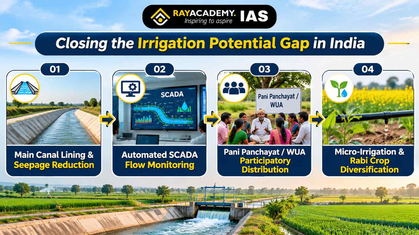
Integrate Canal Lining with Participatory Irrigation Management (Pani Panchayats): Operationalize the Odisha Pani Panchayat Act and NITI Aayog’s water governance guidelines by empowering Water Users’ Associations (WUAs) to co-manage rotational water distribution (Warabandi system), collect water fees, and maintain tertiary distributaries.
Deploy SCADA & Telemetry for Precision Water Accounting: Install Supervisory Control and Data Acquisition (SCADA) gates and volumetric flow meters along Reach-II and the Mangalpur Barrage to monitor real-time discharge, prevent unauthorized water lifting, and guarantee equitable tail-end delivery.
Link Surface Canal Rehabilitation with Micro-Irrigation (PMKSY – Per Drop More Crop): Incentivize farmers in Jayapatna, Kalampur, and Junagarh to adopt drip and sprinkler irrigation fed by pressurized piped networks from the main canal, maximizing crop yield per cubic metre of water.
Promote Climate-Resilient Rabi Crop Diversification: Pair assured Rabi water availability with MSP procurement, seed minikits, and cold-chain support for pulses, groundnut, maize, and horticultural crops—transforming Kalahandi into a diversified agro-processing hub.
Offset Reduced Canal Seepage via Dedicated Aquifer Recharge: Construct percolation tanks, check dams, and farm ponds across the Hati–Tel command area to sustain local groundwater tables alongside high-efficiency lined canals.
Value Addition for Mains
Official Project & Irrigation Benchmark (Nov 2026): The ₹239.13 crore renovation of Reach-II (42.606 km) of the Upper Indravati Right Main Canal targets full realization of its 27,195-hectare irrigation potential (currently 25,846 ha in Kharif and 20,074 ha in Rabi)—directly addressing the IPC–IPU gap flagged across consecutive Economic Surveys as a primary constraint on Indian agricultural productivity.
Policy & Governance Anchor: Operationalizing “Har Khet Ko Pani” and “More Crop Per Drop” under PMKSY—alongside the Mihir Shah Committee’s emphasis on Participatory Irrigation Management (PIM)—demonstrates how modernizing legacy river-valley infrastructure can transform erstwhile drought-prone regions like Kalahandi into models of sustainable agrarian prosperity.
Practice Questions for Active Recall
Prelims Practice MCQ
With reference to the Upper Indravati Multi-Purpose Project and the Indravati River, consider the following statements:
The Upper Indravati Project involves an inter-basin transfer of water from the Indravati River in the Godavari basin to the Hati River in the Mahanadi basin.
The Indravati River originates in the Vindhya Range of Madhya Pradesh and flows eastward to join the Mahanadi River.
Bridging the gap between Irrigation Potential Created (IPC) and Irrigation Potential Utilized (IPU) is a core objective of the Command Area Development and Water Management (CADWM) programme.
Which of the statements given above are correct?
(a) 1 and 2 only
(b) 1 and 3 only
(c) 2 and 3 only
(d) 1, 2, and 3
Correct Answer: (b) 1 and 3 only
Explanation:
Statement 1 is correct: Under the Upper Indravati Multi-Purpose Project in Kalahandi, Odisha, water from the Indravati River (Godavari basin) is diverted across the basin divide into the Hati River (Mahanadi basin) after generating 600 MW of hydropower at Mukhiguda.
Statement 2 is incorrect: The Indravati River originates in the Eastern Ghats in Kalahandi district of Odisha (not the Vindhya Range) and flows westward through Chhattisgarh to join the Godavari River (not the Mahanadi).
Statement 3 is correct: The CADWM programme (subsumed under PMKSY – Har Khet Ko Pani) specifically targets reducing conveyance losses and constructing field channels to bridge the IPC–IPU gap.
Mains Practice Question (GS Paper III — 150 Words | 10 Marks)
"Modernizing aging canal networks is indispensable for bridging India’s Irrigation Potential Created–Utilized (IPC–IPU) gap and ensuring equitable water access for tail-end farmers." Discuss the significance of canal lining and system rehabilitation projects, and suggest institutional measures to sustain irrigation efficiency.
Answer Structure Hints:
Introduction: Contextualize the ₹239.13 crore renovation of Reach-II (42.606 km) of the Upper Indravati Right Main Canal in Kalahandi, highlighting how curbing seepage restores designed irrigation capacity (27,195 ha) across Kharif and Rabi seasons.
Body Part 1 (Significance of Canal Rehabilitation): Explain reduction in seepage/transmission losses, elimination of head-reach waterlogging, equitable water delivery to tail-end farmers, and enabling Rabi crop diversification in drought-prone regions.
Body Part 2 (Institutional & Sustainability Measures): Address challenges like O&M funding deficits and reduced incidental groundwater recharge by recommending Participatory Irrigation Management (Pani Panchayats / WUAs), SCADA volumetric monitoring, PMKSY micro-irrigation integration, and dedicated aquifer recharge structures.
Conclusion: Conclude with More Crop Per Drop, noting that pairing civil canal modernization with community-led water governance ensures long-term agrarian and hydrological resilience.
Take this article with you
Save a reading copy for offline study.


